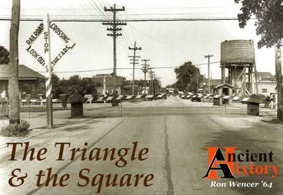
|
APRIL 2020
|
|
|
Jericho
was settled by Europeans in the mid 17th century.
To its south, the empty plain saw no settlement for two
centuries, although it was crisscrossed by many merchants and other
travelers, who went back and forth between the settlements on the North
and
South
Shores
. The hooves of the
travelers' horses, and the wheels of their wagons, slowly carved roads
across the plain. Before one
of the southbound roads got too far from
Jericho
, it forked in three, with each of its fork's tines heading off to a
different
South
Shore
settlement.
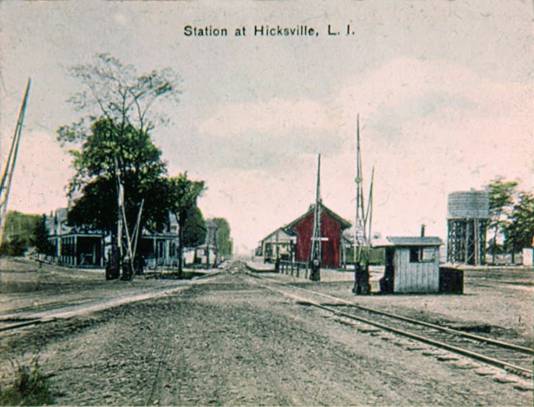
No one saw fit to permanently settle at the forks until the 1830s, and
even then settlement came about because of a quirk - the new railroad
had run out of money, and thus could not build further east.
It constructed a little depot where things had stopped, and
railroad president Valentine Hicks dubbed the place "
Hicksville
." The depot's access to
New York City
and its markets soon attracted people to the area, and a village took
root.
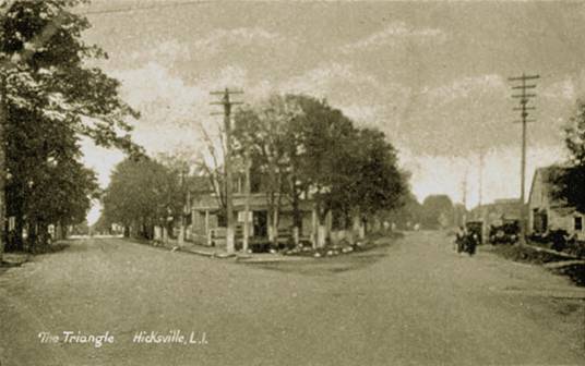
Just north of that depot, the diverging of the roads to
Jerusalem
and South Oyster Bay (i.e., today's
Wantagh
and
Massapequa
, respectively) created a triangular plot of land.
In time, this triangle would become a focal point for the
village. Situated on it, or
across the road from it, would be resort hotels, and the homes of some
of the village's prominent families, with names like Augustin
and Fassbender.
|
|
|
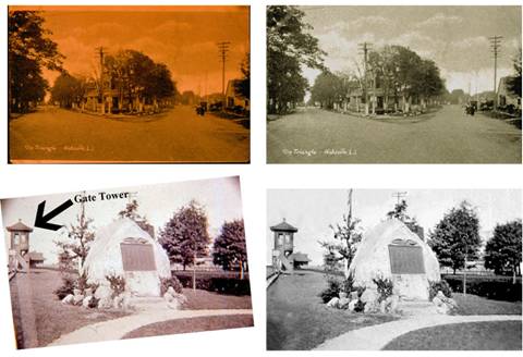
The Triangle, seen looking south from John Street; date
uncertain
Like the 1939 view used at the start of this article,
this image is one of
the Hicksville Public Library Digital Images at https://nyheritage.org
(digitally modified / "restored" by the author)
|
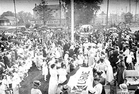
Eventually, the Triangle would become a venue for speeches, holiday celebrations,
band concerts, and even the posting of campaign results on an
election-night. On the first
Memorial Day after the Great War, many hundreds of people paraded to it,
in celebration of the return of those who had gone off in uniform.
For each of the three men who would never return, they planted a
young oak. Hicksvillians
expected that for decades, perhaps even longer, while the trees grew
tall and strong, they would help keep alive the memories of the
sacrifices made by those three men.
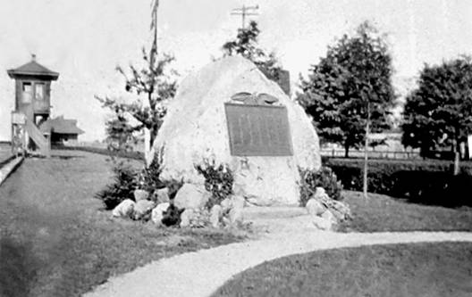
On the following July Fourth, the village unveiled and dedicated
a war monument near those young oaks - an enduring boulder that
already had withstood eons, which proudly bore a plaque with the names
of all those who had served.
|
|
|
Depot Square, probably on July 4, 1919, when the War
Monument
(behind the dais,
near the flagpole) was unveiled and dedicated
Hicksville Public Library Digital Images at https://nyheritage.org
(digitally modified / "restored" by the author)
Note: The Epworth League - the women holding the banner
in the
foreground - was a predecessor of Methodist Youth Fellowship.
|
All in all, the Triangle
(including
Depot Square
, the name given to the open area at its southern edge) was a worthy
little "town square" - but things change.
Almost
any town's history shows that its "social center" changed as time
passed. Consider
Manhattan
's Union Square. When I was
a student, it was at best a rundown, sketchy neighborhood.
Yet, in the 19th century it was proudly given its name
because it marked the junction - the union - of Broadway and Bowery
Road (now Fourth Avenue), which then were the two most prestigious
avenues in Manhattan. On
the site of today's Consolidated Edison offices once stood the
original Academy of Music, the
first successful opera house in the country.
The phrase Union Square
once implied elegance. Again,
things do change.
Today,
part of Hicksville's Triangle
survives in the form of Kennedy
Park - much smaller, and fatally cut in two by a swath of noisy
traffic. Although
well-landscaped and appealing, the place can never be the focal point
for the village in the same way that the combination of Depot
Square and the Triangle
once was.
Although it is not surprising that the gathering place north of the
tracks did not endure forever, it is notable that the old Triangle declined with such abruptness.
Let's review the unstoppable forces, and one bizarre event,
that accelerated its demise.
|
***
|
|
Hicksville
Once Was the Railroad's Town
|
|
|
|
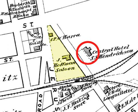
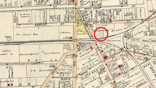
The Triangle Vicinity in 1873
Atlas
of Long Island, etc., Beers, Comstock & Cline, 1873
(excerpt)
digitalcollections.nypl.org
|
In any number of old towns in the Eastern U.S., people can point at
something and lament, "It was never the same once the railroad
came." It may seem
disingenuous for Hicksvillians to do that - after all, the railroad
was there first, and the original settlers chose to live and work right
on top of it. Nonetheless,
it is fair to observe that as time went by, the LIRR
had to encroach - and it did encroach - on the village, and its
spread critically affected things that had been established close to the
tracks.
Railroading steadily matured in the 19th century, and the
things it did got faster and a lot bigger.
As longer trains ran more frequently between Jamaica and points
east, each carrying more people than Valentine Hicks could ever have
imagined, the towns and villages that depended on the railroad had to
withstand many changes. Yet,
look at the meager LIRR
infrastructure (basically only track, albeit with a small depot and
platform) that existed as late as the 1870s.
It was nearly identical to how things had existed from the start.
After 40 years, nothing built or laid out in Hicksville was
closer to the railroad than in 1837.
Change was overdue. Because
the Main Line between Hicksville and Jamaica had two-way traffic, but
much of it was still only a single track, demand was pushing closer to
capacity. Thanks to the
Island's prosperity, more goods and produce were being shipped as
freight, but there was little room for handling freight at Hicksville.
A future rail connection to Manhattan was inevitable, and when it
happened, the need for still longer passenger trains, and more of them,
would increase sharply. For
all these reasons, the railroad needed larger locomotives, and they
would burn more fuel, and use more water - things which had to be
stored not only at Jamaica, but also at key points to the east.
|
|
|
A view which existed for only one year: looking west from
Broadway
at the 19th century depot and the LIRR water tank.
https://nyheritage.org
(source unconfirmed as of this writing)
The tank was constructed in 1908, and the depot removed in 1909.
|
Thus, between the 1880s and 1916, a series of projects nibbled away at
the properties that adjoined the
LIRR, netting these results:
|
§
|
The
little depot no longer stood near Broadway.
|
|
§
|
A
second track, adjacent to and north of the original, had been
added to the Main Line, all the way from Jamaica.
|
|
§
|
Immediately
west of Jerusalem Avenue, a new passenger station had been
erected.
|
|
§
|
To
the west of the new station, the old LIRR
property line had been pushed north, far enough into the
properties on Barclay Street to accommodate a yard that could
hold more than 120 boxcars.
It had a freight depot and a Railway
Express Agency (think FedEx
on rails) facility.
|
|
§
|
With
the new yard facilities in the way, Newbridge Road could no
longer continue north across the tracks; it had been rerouted,
so as to curve right and subsume Herzog Place.
|
|
§
|
In
the Triangle, some
distance north of the tracks, there now stood a 50,000 gallon
water tank, used exclusively to replenish locomotives' water
supplies.
|
|
*
|
A
Sidebar
Readers
may never have paused to realize that the steam which is emitted so
copiously by a steam locomotive comes from water stored in the
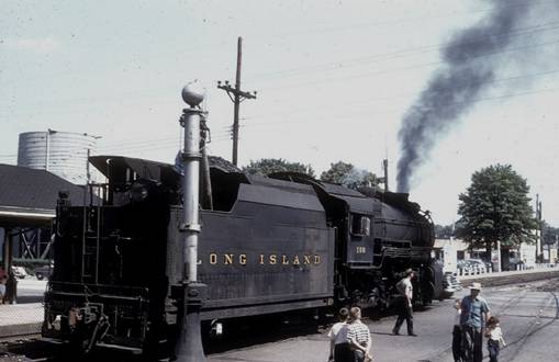
locomotive's tender, in a tank underneath the tender's coal bunker.
As locomotives usually consumed water twice as fast as they
consumed fuel, stops to replenish water were common.
|
|
|
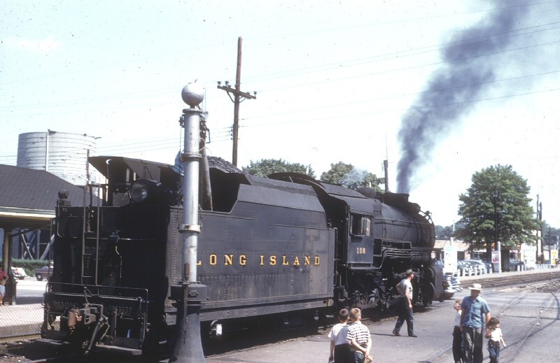
1954: LIRR #108 taking on water at Jerusalem Avenue
Collection
of historian Art Huneke, viewed at
http://www.trainsarefun.com/lirr/hicksville/PRR-H10s-108_taking-water-Hicksville-1954_ArtHuneke.jpg
What you're seeing: With the crossing gates raised, an
automobile is starting to
pass in front of the
stopped locomotive. Underground
pipes connect the LIRR
water tank (visible
in the distance, left) to the "water column" in the
foreground.
Its spigot directs
water down into the filler pipe of the tender's water
reservoir.
|
|
***
|
|
Meanwhile,
In the Village
|
That
probably was more than enough about railroading for you - but in a
way, that was the point. The
people who had to live with the changes must have got fed up, too.
As can be seen below, by 1914 there was growing demand for real estate
in central Hicksville - and the LIRR
was would acquire still more. To
get an idea of the railroad's "thickening," look at how close the
tracks were to the original part of the Grand
Central Hotel in 1873 (circled on both this and the earlier map) as
opposed to 1914.
Other
things also were working to squeeze existing real estate.
The change from agrarian to suburban living had begun; there were
more people, and most of them wanted to live close to the railroad
station. The rise of the
automobile already was creating the need for parking lots; roads had to
be paved and widened, to accommodate more traffic and more parked
vehicles.
For a while, the north of the Triangle
looked the same (if slightly narrower once the roads were paved), but
people who lived in the area noticed qualitative changes.
With more potential workers living in the village, and with
better rail freight services, small industry was growing.
There also were new retail businesses, like car dealerships and
garages. Business was
penetrating further into Jerusalem Avenue, and the old, established
families in the Triangle area
started to think about relocating.
|
***
|
|
When
the camel's back breaks, the final straw is no more to blame
than the first.
Old Wencerian Proverb
|
Enough
finally became enough.
In the deepest hour of a December night in 1914, an extraordinary event
occurred. With no warning, a
structural failure caused the
LIRR's water tank to spontaneously explode.
50,000 gallons of water crashed straight down into the Triangle,
noisily triggering a short-lived tsunami.
The sound awakened people throughout the village, but to those
who lived nearby, noise was not the concern.
A number of houses did not withstand the wave and were flooded,
including the home of Charles Fassbender of the Bank of Hicksville.
|
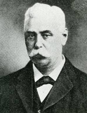
|
|
Charles E. Fassbender, Founder, Bank of Hicksville
Hicksville Public Library Digital Images at https://nyheritage.org
(digitally modified by the author)
|
Despite
protests from some townspeople and the local press, the railroad
promptly replaced the old tank with another one, constructed in
precisely the same place. It
did not help the railroad's image that in January, three weeks after
the disaster, the hastily-built replacement sprang a leak.
A thick, irregular, monolithic ice sheet covered the breadth of
Jerusalem Avenue, rendering it impassable.
Those three weeks likely accelerated change in the Triangle. Long-time
residents began to move. House-mover
Frank Kunz had unexpected work. He
moved one house to West Marie Street (a street which people now thought
more fashionable), to be extensively renovated.
A second structure was moved to a new address on Jerusalem
Avenue, further from the water tank than before.
Repairs on the Fassbender house would not begin until June, as a
lawsuit for damages had to be settled first.
Regardless, the Fassbenders moved a few blocks east.
Although Depot Square was
still used, it now was less suitable for concerts or events that
required a solemn dignity. Traffic
and train noise was louder and more frequent.
With more industrial properties nearby, and with fewer houses,
gardens, and trees, it was less pastoral.
The infamous water tank loomed over it.
Furthermore, a gate tower - the lookout point for the person
who remotely raised / lowered the crossing gates on Broadway and
Jerusalem Avenue - had been nibbled into the Square.
Today, the tower might look quaint to fans of c.1900 railroad
architecture, but I'd wager that the villagers of the 1920s found
little appeal in its being there.
|
|
|
Depot Square c.1920; at left is the tower used to control
the crossing gates.
http://www.trainsarefun.com/lirr/hicksville/hicksville.htm
(digitally modified)
The photographer did what s/he could to hide the
unsightly water tank, but a
corner of it can be seen poking up behind the upper-right edge
of the boulder.
|
But
where else in center of Hicksville was there a suitable public space?
Thus, during World War I, the village's Service Flag banner was
proudly raised in the Square,
so that everyone who came through downtown Hicksville would see how many
young people the village had sent to war.
Afterwards, the War Monument was put there, and the oaks were
planted there, in the belief that Depot
Square would always be at the village's core.
Year after year, it grew less and less special.
Prophetically, one of the three oak trees withered, possibly from
the incessant exposure to the fumes of railroad and traffic.
By the end of World War II, everyone agreed that the Square was not the place to put the next monument.
A dignified, quiet corner of the High School grounds, not very
far away on Jerusalem Avenue, was chosen, and in 1947 the boulder was
transported south to be with it.
Thanks to the magic of bulldozers and asphalt, Depot Square soon receded into oblivion.
In its place, Hicksville got a new diner.
Ironically, its damage done, the LIRR
water tank soon disappeared as well: in 1955, the railroad stopped
using steam locomotives, and it had the tank demolished.
More
Info
It
should not be a surprise that this topic touches upon other things which
Ancient Hixtory has covered.
As noted below, past articles provide more depth about several
topics, and can be accessed by the links provided here:
|
Link
|
Description
|
|
1908/Hixtory.htm
|
Hicksville's
beginnings;
When tunnels made it feasible for commuters to turn L.I. into
suburbia
|
|
1806/hixtory.htm
|
WW
I brings the Service Flag phenomenon to Hicksville
|
|
1905/Hixtory.htm
|
The
Hicksville men who died in WW I;
Creation of the WW I Monument
|
The
Distorting Lens of Time
I
want to expand on a point I began to make here some months ago.
Many times, the quality of the only online photograph of a given
subject suffers for at least one of these reasons:
|
§
|
It
was created under difficult circumstances.
|
|
§
|
It
was shot without adequate awareness of film and lighting
constraints.
|
|
§
|
Inferior
film or processing was used.
|
|
§
|
The
resulting picture was stored improperly.
|
I
feel that such flaws usually detract from what the photo should
communicate. And so, each
month I spend a significant portion of the time I devote to Ancient
Hixtory trying to negate the worst flaws in the best photographs I
have found. Two examples
follow:
The glorious "Hicksville Orange" of the first photograph probably
resulted from using outdoor color film with indoor incandescent light.
Digitally removing the hue while trying to maintain proper
contrast resulted in a less crisp image.
The second photo appears to have been shot through a reflective pane of
glass (likely the glass of a picture frame), using color film to capture
a monotone image. Dark
"fringes" in the corners indicate either a poor lens that failed to
illuminate the film evenly, or an improperly-fitted lens hood.
As I wanted to give readers a good idea of what Depot
Square looked like, without distractions, I leveled the horizon and did some terraforming
- aka faking.
I digitally created land and vegetation to fill in the absent
corners.
I
hope that historians of the future have an easier time with today's
digital pictures.
Ciao!
Please Stay Healthy - I have Very Few
Readers As It Is; I'd Hate to Lose Any!
|